Coastal and compound flooding
Coastal flooding: surge, sea-level rise and rain together
On a coastal site, flooding rarely comes from one source. AquaSWMM's 2D engine holds a tide or surge level on the open-water edges of the grid while rain falls on the land, so you see what each source does alone and what they do together. Below is a screening study we ran on the Indian River Lagoon waterfront in Titusville, Florida.
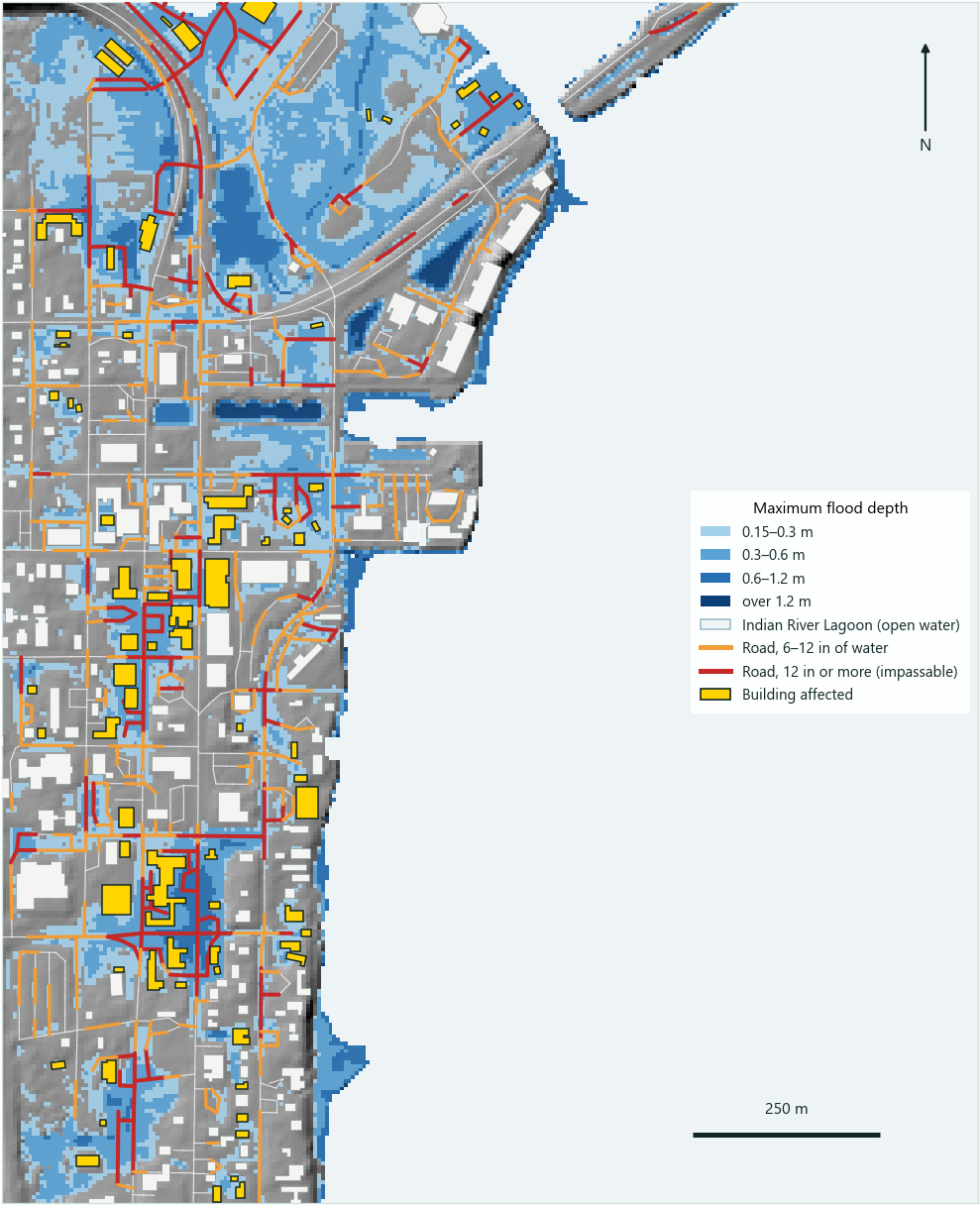
How the model is built
- Terrain: USGS 3DEP 1 m lidar, resampled to a 5 m grid (128,000 cells) with drainage channels burned in.
- The lagoon:
STAGEboundary segments hold the water level on every open-water edge of the grid. A segment takes a constant level or a time series, so a surge hydrograph from a NOAA gauge, ADCIRC, SLOSH or P-Surge goes in directly. - Rain: NOAA Atlas 14 24-hour design storms (2- to 100-year) on the grid.
- Surface: Manning's n by NLCD land-cover class; building footprints block flow.
- Exposure: every road segment and building is scored from the maximum-depth grid: caution at 6 in of water, impassable at 12 in (NWS "Turn Around, Don't Drown").
[BOUNDARY]
OPEN
SEGMENT Tide_NORTH_1 STAGE 1.067 EDGE NORTH 518770 518835
SEGMENT Tide_NORTH_3 STAGE 1.067 EDGE NORTH 519530 520550
SEGMENT Tide_SOUTH_4 STAGE 1.067 EDGE SOUTH 518975 520550
SEGMENT Tide_EAST_5  STAGE 1.067 EDGE EAST  3164215 3165815
[ROUGHNESS]
CLASSES "data/nlcd.tif"
[BUILDINGS]
BLOCK "data/buildings.geojson"
With a pipe network, the same water level goes on SWMM outfalls as a TIDAL or TIMESERIES boundary, and 1D-2D coupling lets the lagoon back up through the outfalls onto the street.
Start from the right water level
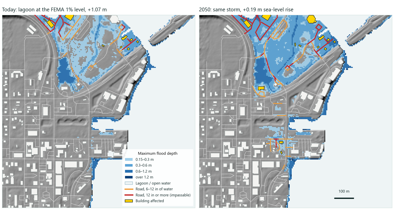
The nearest NOAA gauge with tidal datums is on the ocean side, 30 km away. The northern Indian River Lagoon is nearly tideless, so the ocean's high tide is the wrong boundary here: everyday lagoon high water is about 0.35 m lower. At everyday lagoon levels, today or in 2050, no road on this block floods from the lagoon alone. Storm levels are another matter: they reach the lowest quarter of the road network.
Which water level? The lagoon is not the ocean
Water levels (left) against road elevations on the block (right). Blue = everyday lagoon levels; orange = storm levels and the ocean gauge; dashed = road elevation percentiles.
Sea-level rise: 0.19 m doubles the road cut off by surge
Compound flooding: rain on a high lagoon
Rain does most of the damage on this shore, but a high lagoon makes every storm worse: low streets can't drain while the water's edge sits above them. Hover over a bar for its value; the table under each chart has every number.
Road cut off (km, 12 in of water or more)
Rain storm (24-hour, NOAA Atlas 14) on top of each lagoon level.
- Lagoon at everyday high water
- Lagoon at the FEMA 1% level
- FEMA 1% level in 2050
Table
| Rain | Lagoon at everyday high water | Lagoon at the FEMA 1% level | FEMA 1% level in 2050 |
|---|---|---|---|
| No rain | 0 | 0.68 | 1.39 |
| 2-yr | 1.2 | 1.89 | 2.82 |
| 10-yr | 2.33 | 3.09 | 4.13 |
| 25-yr | 3.34 | 4.21 | 5.17 |
| 100-yr | 4.93 | 5.93 | 6.83 |
Buildings affected
At least 6 in of water along a quarter or more of the building's edge.
- Lagoon at everyday high water
- Lagoon at the FEMA 1% level
- FEMA 1% level in 2050
Table
| Rain | Lagoon at everyday high water | Lagoon at the FEMA 1% level | FEMA 1% level in 2050 |
|---|---|---|---|
| No rain | 0 | 9 | 14 |
| 2-yr | 21 | 31 | 35 |
| 10-yr | 37 | 47 | 50 |
| 25-yr | 44 | 56 | 60 |
| 100-yr | 66 | 76 | 79 |
What this is, and is not
- Screening, not design. The results are not calibrated to observed floods. Don't call them validated.
- AquaSWMM does not generate storm surge. It takes water levels, constant or time series, from gauges, FEMA studies or surge models (ADCIRC, SLOSH, P-Surge) as a boundary condition.
- A fixed lagoon level: no waves, wind-setup gradients or storm timing in this study.
- Storm drains were not modelled here, so there is no backflow through outfalls. AquaSWMM can couple the network when one is available.
- Design rain and the 1% water level are not a joint probability; pairing them is a scenario, not a return period.
- Terrain from USGS 3DEP; roads and buildings from OpenStreetMap; flood zones from FEMA's NFHL. "Affected" is water along a building's edge, not first-floor flooding.
Have a coastal site where rain, tide and pipes interact? Groundwater matters there too: see aquifer modelling. Questions: email us.